Helvellyn Entire
Route Information
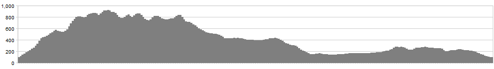
Stats: 25 miles and 4400 feet of ascent
OS Map Link: ![]()
Refreshments
How big is your rucksack? This is a big, breezy mountain experience so don’t expect a café round every corner. On a good day, you might be able to get an ice cream at the car park by Thirlmere, but that’s your lot.
Character
This is it, the Big One, the biggest legal high in the land. Not only is Helvellyn generous with its altitude, not only does it bear a name like an epic poem but it offers an unusually generous choice of routes to its summit with no fewer than ten bridleways setting off from the surrounding valleys. That offers the enthusiastic and the mathematical a hundred different routes on the hill. This route tackles the ridge in its entirety, south to north, to get the prevailing wind on your back and to avoid the skull-splitting descent to Grizedale Tarn.
Route
1. Start from Grasmere and take the good bridleway up the side of a whitewashed house with a public postbox. After a mile, dink right across the stream and set off up the steep, grassy pull up through the bracken-clad slopes of Little Tongue.
2. If you have an altimeter, keep an eye on your height, because the climb gets sketchy around 450 m. Head off to the right on a curving contour that converges with the more substantial footpath coming up from Tongue Gill.
3. Go up through Hause Gap and take a technical track sloping down to the outflow of the Tarn. Cross the outflow and double back on yourself slightly to shoulder the bike and pick up the strong zigzags up Dollywaggon Pike.
4. At 800m, a world of rideability emerges from nowhere and you can pedal merrily across the western flanks of Dollywaggon and Nethermost Pikes before the final steady pull to Helvellyn summit. Expect to get a cheer from the walkers huddled in the cruciform shelter as you admire the views to north and south.
5. If you’re in mist, you’ll need to pay close attention here because there are three candidate ridges dropping away and you don’t want to be messing with either Swirral or Striding Edge on a bike. From the summit, head WNW on a good track. Where it re-joins the steep drop, off, climb a little to Helvellyn Lower Man and pick up the north ridge. You’ll need to decide whether this is rideable based on your abilities, the density of walkers and your commitment to reducing erosion.
6. After that, the way should be fairly obvious, over the switchback of Whiteside (don’t be tempted east, or you’ll end up in Glenridding, miles from your base), the rocky summit of Raise, then the more rounded Dodds – Stybarrow, Watson’s (this bit really is elementary) and Great.
7. From the top of Great Dodd, head north a little way and pick up a strong rake sloping down to the north-east. Head towards the little rocky tor of Randerside and keep following the track through tumble-forgiving peat and heather to the Old Coach Road.
8. Turn left on the Coach Road and drop down to St John’s in the Vale.
9. Turn left on the B5322 and follow this until it joins the A591.
10. Follow the A591 south until the car park at Swirls (NY316168). From the car park, pick up a permitted bridleway rising across the flank of Thirlmere. Keep following this south through the forest, looking out for those elusive red squirrels as you go.
11. When the trees end, zag back downhill and rejoin the main road where the lakeside road comes in from Wythburn at NY325129. If you’re a tarmac-averse purist, you could pick up the short bridleway from Steel End farm to the top of Dunmail Raise but most mortals will be quite keen to get back by now and gratefully join the road for the fast drop to Grasmere and a well-earned fistful of gingerbread (a prize Clint Eastwood never quite attained).
Click below for gpx file

