Howgills Road Loop
Route Information
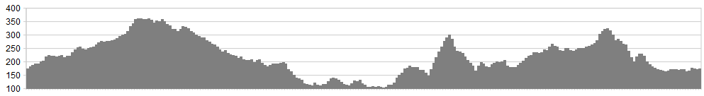
Stats: 47 miles and 3400 feet of ascent
OS Map: ![]()
Refreshments
Ample in Kirkby Stephen at the start and finish. Sedbergh has some great tea rooms and places to grab a bite to eat. Orton also has a great little spot for tea.
Character
This is a really scenic route, on quiet roads. There are some great ascents and descents that swoop along the rolling Howgills, with some epic views. You can pick your own start point for this loop. Parking at Kirby Stephen, Sedbergh, Orton, Garsdale so it doesn’t matter where you start from.
Route
1. Park at Kirby Stephen. Take the B6259, which is signposted to Nateby, Hawes. Ascend the Mallerstang, up to the Moorcock Inn.
2. At junction turn right, pass by the famous Garsdale Head Station on the Settle-Carlisle line and follow the A684 to Sedbergh. Enjoy the amazing views of the Howgills on the approach to Sedbergh. Go into Sedbergh turn left towards the town centre. At the T junction turn left then right and out of Sedbergh on the A684 towards Kendal.
3. After crossing the river Lune (narrow bridge- watch for oncoming traffic) turn right on the B6257- signposted Tebay. Good views of the western side of the Howgills. The road climbs steeply from Beckfoot under the M6 up to join the A685.
4. At the junction turn right on the A685 towards Tebay and enjoy the long fast descent into Tebay. Go through Tebay to the roundabout. Take B6260 sign posted Orton.
5. At entrance to village of Orton look out for and take left turn onto B6261 signposted Kirby Stephen. Turn left soon after this at junction signposted Soulby/Asby- climb steadily up past Sunbiggen Tarn- careful over the cattle grids!
6. Continue to cross roads. At cross roads go right signposted Soulby. Descend into Soulby and turn right back to Kirby Stephen.
click below for gpx file


