Rhayader Classic MTB
Route Information
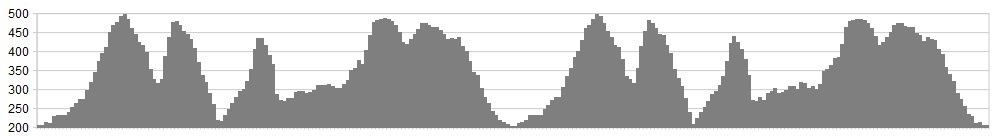
Stats: 21 miles 3376 feet of ascent
OS Map: ![]()
Refreshments
Rhayader and the Elan Valley have several good cafes, a visitor centre and a wealth of accommodation choices at all price points.
Character
A hilly ride with plenty of technical descents to test your skills and grab some grins, together with lung busting climbs, mixed with amazing scenery and a stunning finish to top things off.
Route
This classic route is taken from What Mountain Bike and remains a great ride in any book. We simply can’t improve on it, so it seems sensible to stick to it.
Start/Finish Clive Powell’s bike shop, at grid SN969/679 Maps OS
Landranger (1:50,000) No. 147 Elan Valley & Builth Wells. Or Garmin GB
Discoverer 1:50K Southern England and Wales (GPS).
1. From Clive Powell’s bike shop, turn right out of the door, along the B4518, down and over the bridge out of town. Take the road on the right (just past the cycle path on the left), signposted Mountain Road, Aberystwyth, uphill for 4km to the top. Turn left onto a clear track that drops to a ford and small dam.
2. Cross the dam and bear sharp left to cross a boggy section and pick up a stony track, climbing steeply to the top, where a waymark directs you right.
Continue on a grassy track that climbs past the trig point, and bear right at a fork. Continue down to a gate. Continue through fields, bearing left through a gate on the bridleway, past a house and stream, then uphill past a house (on your left).
3. Turn left on the bridleway, climbing steeply to/right at a fork, to/ahead at a crossroads on flatter ground. A track joins from the left, cross a boggy section (numerous options), joining the better stony track shortly. Ford a stream and keep left at a fork, following the main track downhill to a drive.
4. Bearing right, then left by/into the woods on a bridleway, fast singletrack descent. Turn right on the road at the bottom. Keep left at fork, past a cottage to a bridleway turning on the right through a gate. Climb uphill gently.
5. When the hills get steeper, just beyond a gate, cross a stream and turn right on very faint track (not left on more obvious track), up the steep valley (walk) with stream on your right. At the top, bear to left around a boggy section, then right, downhill on good singletrack, bearing left across a stream uphill, then steep drop downhill, with a technical rocky bit at the top.
6. Turn right on the road at the bottom, by the reservoir edge, then fork right on the NCN route to climb into the trees. Keep left at a fork, passing the dam, alongside the reservoir, passing Craig Goch dam (to your left). The track starts to climb steeply uphill, becoming faint but improving at the top. Drop down to a ford and back up to a road.
7. Turn left on the road for 1km to a wide track at the top. Continue on this taking in one small climb. Follow the red arrow markers (left then right), downhill all the way to a house and keep ahead, through a gate to a road. Turn right on this, then left at the T-junction, to the B4518 and turn left on this, over the bridge and back into Rhayader.
click below for gpx file


