Swaledale Twist and Shout
 Route Information
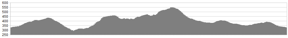
Stats: 15 miles with 1810 feet of ascent (steep!)
OS Map: ![]()
Refreshments
Leyburn – the cafes, bakers and pubs are many. Andy’s on the Market Place is a reasonably priced bakery.
Character
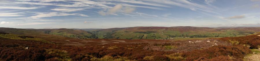
This is a hard route from the word go. The tracks are great but tricky in places with technical twists. They will shake, rattle and roll you through Swaledale. The superb section of singletrack will make you twist and shout. If you’re on your own – be aware that this has tricky sections with sneaky drops. If riding in a pair or group – lead rider ‘enjoy’ as there are a number of surprises along route. The steep climbs will test us all but the views and descents are awesome.
Route
1. From Leyburn head up and towards Grinton, parking in the small area near the bridge and army ranges (1/2 mile from the crossroads).
2. Turn left onto the road, and then almost immediately left again through the 5 bar gate and onto the track through moorland. Take the first track on the right and climb steadily, passing a shooting box on the way, before the well-made track moves into sweet singletrack and up to the gated wall.
3. Once through the gate, descend on the twisting singletrack, passing a small hillock (bomb crater style) as you tackle the tricky descent through heather and ferns. This is where a good leader will shout the obstacles to friends … or enemies (maybe not!). There is lots of scope for an ‘off’ through this section. It is however one of the best sections of technical singletrack anywhere in England.
4. The singletrack eventually merges into good double track, joining the bridleway downhill to the old lead mining buildings and flue at Cogden Moor. Take a breather here before continuing on and joining the road at Grinton Bank, then turning off left shortly afterwards onto a singletrack bridleway that rises and falls, with a tricky climb out of a gully before crossing another road.
5. Singletrack merges to double track, then down to the fording Grinton Gill stream, climbing steadily out to a junction of tracks. Take the track ahead which climbs ‘High Harker Hill’ (OS Maps), then dropping and rolling along the valley with some neat little sections to keep you on your toes.
6. The excellent track then climbs steeply, with expansive views to the left along Swaledale. Just below ‘Kendell Bottom’ (OS Map) a bridleway to the left is seen by a small pile of stones just off the track. This is extremely tricky in ascent (but delightful the other way); continue along the track instead, keeping off the moor and making an easier journey to the Apedale track junction. However, be aware of shooting parties and respect their position and land. Staying on the track will ensure that the moorland birds are also not unnecessarily disturbed.
7. This double track soon meets a T junction where we turn left and climb on the loose surface to the summit of the Apedale Road, passing old mine workings and scree debris on route. At Apedale Head the track begins its descent. This is fast, loose, tricky and twisty and care should be taking. Do not over brake. Instead, modulate your brakes and keep a good line, making the most of this classic descent track
8. Stay on the Apedale Road, joining the highway and turning right for a short distance towards Redmire. Then take the track approximately 1/2 mile down on the left, over Thorney Bank Hill (OS Maps). Once again, please be respectful of landowners and shooting parties, who allow this track to be used in the Dales. At old building on your left, take the track off to the left, climbing Cobscar Mill, with a pond seen to your right. At the next junction of many tracks, do not turn immediately left, but do take the second track from the left, almost straight on and up the hill.
9. Climb steadily to a further track junction by a memorial cairn, taking the right hand fork which eventually leads back to the road and the car with a steady descent. Time then for a brew!
click below for gpx file


