Todmorden West MTB
Route Information
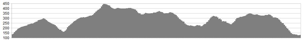
Stats: 14.8 miles & 2685 ft of ascent
OS Map: ![]()
Refreshments
Todmorden has a good choice of eateries, including great veggie options. Bikes shops in the area are renowned for their service, and the place is all around friendly. Nearby Youth Hostels provide cheap accommodation options, and the town has several B&B options as well.
Character
Great little route around the valley, taking in some excellent singletrack, with a few testing climbs along the way.
Route
1. From the town head into Bankside and begin the climb, taking in the bridleway that ascends Shoebroad Lane to the junction with Long Hey Lane. Follow this until it joins Lumbutts, turning left for a short distance, then picking up the Pennine Bridleway on the right.
2. Take the Pennine Bridleway as it rises and then falls to Walden, along some excellent tracks.
3. At Walden cross the road from St Peters Gate to Inchfield Road opposite, climbing this epic steep road, and giving yourself a pat on the back if you clean it, then riding the continuation into Foul Clough Road, along the mixed track as it rises and skirts the hills, before climbing steeply again, all the way to the trig point.
4. Go through the gate and across the tricky ground now, where technical singletrack guides you down the valley and onto the double track of Limers gate (BW). Descend this all the way to the scrubby and difficult to locate track junction above buildings on the right. If you hit the new fencing, then you’ve gone too far
5. Turn down right to the A646 Bacup Road, and head right before dinking off left onto the indistinct and tricky to follow moorland bridleway that rolls along the moor beneath the wind farms, crossing Acre Nook Clough, as you head on singletrack to the junction with Tower Causeway – turn left here.
6. Now race down this bridleway, eventually joining the A646 west at Cornholme. A short distance along the A646 a car park is seen on the right. Take this and pick up the bridleway that rises and falls and rises again, all the way to the village of Shore, passing Brown Birk’s Farm along the way.
7. At Shore a sign for Raw Hey Farm is seen on a post by a 5 bar wooden gate. Opposite this on the right is Shore Green (Cul de Sac) – take this. The bridleway is picked up at the left fork, after passing white washed buildings on the right.
8. The left hand fork dinks up left again before the cottages, then dinking right into the bridleway of Bluebell Lane a short distance further on.
9. Stay on this bridleway to Dyke Farm, then heading left for a short distance, to a T junction of tracks, taking the right hand turn and descending this excellent track all the way to Hole Bottom (Yes, Hole Bottom folks) and back down to Todmorden.
click below for gpx file


