Tour of Coniston
Route Information
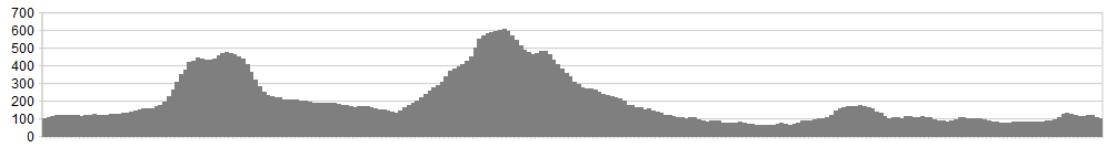
Stats: 23 miles and 3,500 feet of ascent
OS Map Link: ![]()
Refreshments
If you do this ride from the foot of the lake, you’ll find bags of choices in Coniston village. The Meadowdore cafe is welcoming and has plenty of space outside for muddy bikes and soggy riders.
A word of warning, though; if you ride from Coniston itself, the only replenishment will be at the start and finish. If your ‘sac is insufficiently stocked, this could lead to desperate measures like eating fistfuls of Sweet Cicely from the verges.
Character
This ride links together the magnificent Walna Scar route with the equally-impressive
Parkamoor ride to make a monster. The linking route, for once, does not feel at all like a filler – the crossing of Subberthwaite Common is a real highlight. In wet weather (I rode it after the wettest June in British history, followed by five days of continuous rain as July took over), the section between Hole Beck cottages and Walna Scar can be draggy but the rest is a stone-based delight. On a clear day, the views from Walna Scar and Parkamoor are as impressive as any in the Lakes.
Route
1. From Blawith, take the unsigned road west from the phone booth.
2. Turn right immediately after the cattle grid, itself just after Houkler Hall.
3. At the three-way fork, take the middle track, signposted to Woodland and Cumbria Way. This is a superb section of singletrack, twisting over stonechatty common-land, creamy-scented with bracken.
4. Where the track levels out, just after a watersplash, fork right (no signs), swooping down to a big watersplash – so good you might want to turn round and do it again.
5. After the stream, ignore the track heading up to the right and shadow a wall northwards on singletrack. Drop slightly past an antique Bamford reaping mower and through a gap in the fence. The path is sketchy hear but you’ll soon converge with a better track coming up from your left.
6. Go over the slight brow and drop towards Haveriggholme. Here there are a number of options open to you. You could whizz down the lane almost into Torver and climb on either the A593 or Hummer Lane (Hummer Lane has the advantage of bypassing the draggy section over Hole Beck) . You could cross the ladder stile just before Haveriggholme and carry the bike up to Troutal Hall. But, like Freddie Mercury, you want to ride your bicycle, don’t you? So the route mapped shows a compromise – a 2 minute carry up to the railway line and a trundle to the road.
7. From Hole Beck cottages follow good signs (but a faint track) diagonally up and to the right. Pick up the stone wall running ENE then NNE to turn left at Hummer Lane.
8. Fork right onto the forest road and, after a right turn, pick up a well-concealed left turn dropping steeply through scratchy conifers and twisty roots. Turn left at the bottom and follow fire-road down over a wooden bridge, forking right (and slightly up) on more singletrack, the sign well-hidden when the vegetation is high. Drop with considerable interest to Water Yeat Bridge.
9. Climb on tarmac to Stephenson Ground and take the right turn (careful, there are two) signposted to Walna Scar. Traverse above the gorge of the River Lickle, and then climb up an increasingly difficult series of zigzags to gain the plateau above Natty Bridge.
10. Skirt White Pike on the Duddon side, with the valley providing the perfect foreground for the Scafell grouping. If in mist, hold your course as NNE, contouring to the abandoned mine workings. Then turn right for the final 200m pull to the watershed of Walna Scar.
11. The descent is superb, zagging on gravel. Either keep left to the main tarmac road or take one of the right forks to make a more adventurous descent.
12. From Coniston, take the Hawkshead road skirting the head of the lake on permitted bridleway. Climb up and to the right (towards Brantwood)
13. Turn left on good bridleway at How Head, climbing with interest to an open field with three dead trees. Ignore the farm track climbing from here and contour into the woods.
14. Keep heading broadly south, ignoring offers of bridleways on the right and fire-roads on the left. Where the fire road dinks left, go straight on through trees to a magnificent escape from all that arboreal claustrophobia and a lofty perch above the lake.
15. Head south along the crest of the slope, dipping down to the house at Parkamoor, and keep on going all the way down to High Nibthwaite.
15. Cross Bouthrey Bridge (rebuilt 2011 after flooding) to the start.
Click below for gpx file

